Highlights from Chapter 2:
Regional Updates
This chapter provides updates on our progress in advancing the statewide system in three regions: the Central Valley, Northern California and Southern California. Within each region, high-speed rail will connect to urban and regional public transportation services, particularly at multimodal hubs, to enhance access and mobility throughout California as shown in new regional connectivity maps on the following pages. The regional maps show high-speed rail routes and stations, as well as connections to existing and planned transit services and major airports.
The Central Valley section provides an update on current construction progress and the Authority’s plan to develop a line connecting Merced, Fresno and Bakersfield for initial high-speed passenger service. Northern and Southern California regional overviews feature updates on our collaboration with regional partners and the regional bookend projects that the Authority is helping fund. Mobility, community and environmental benefits are also featured including travel times between regions that show how quickly passengers will travel up and down the state.
Regional Connectivity
This chapter introduces regional connectivity maps showing how high-speed rail connects to urban and regional public transit services within each region.
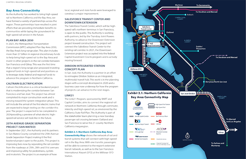
Text description of Bay Area Connectivity
Overview
This is a sample of one of the regional connectivity maps from the full document. This Bay Area Connectivity map shows how the planned California high-speed rail line connects to other regional transportation systems including the Amtrak Capital Corridor, Bay Area Rapid Transit, VTA Light Rail, Amtrak San Joaquins, San Francisco Muni, Caltrain, Altamont Corridor Express, intercity bus service and proposed passenger rail service to Monterey County.
Regional Highlights
Each of the three major regions are presented in this chapter as two-page summaries showing a regional map and highlighting community benefits of bringing high-speed rail to the region.
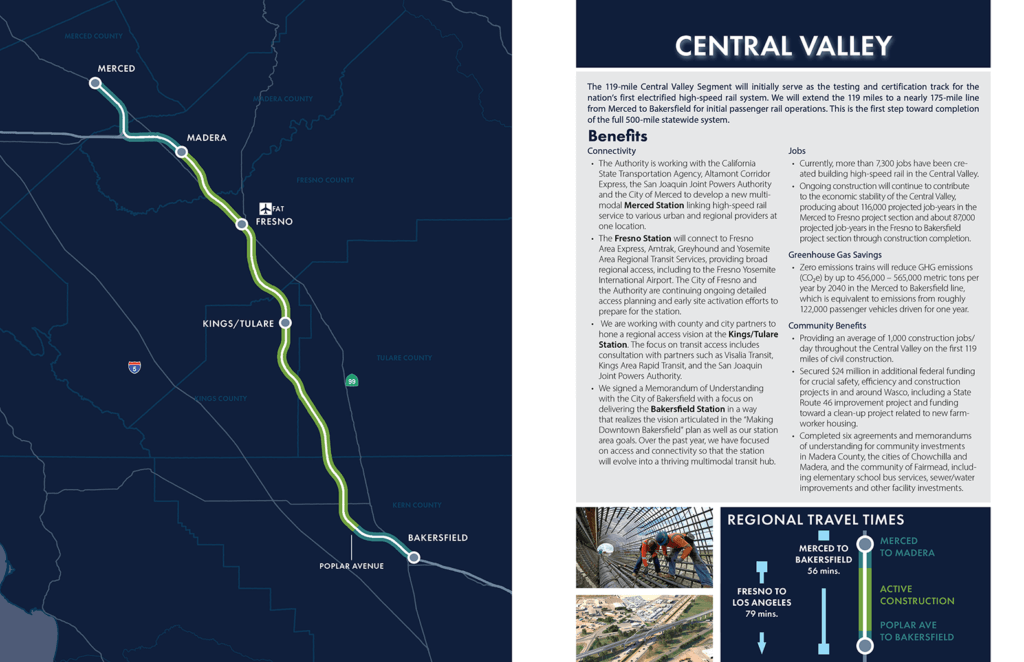
Text description of Central Valley regional highlights
Overview
The Central Valley spread gives an example of one of the regional spreads featured in the full document. The map shows the planned high-speed rail line from Merced to Bakersfield. Also presented are an overview of the region including connectivity, jobs, greenhouse gas savings and community benefits, as well as regional travel times.
Project Sections
Project sections in Northern and Southern California are presented in two-page summaries featuring a map of the section and key aspects including project section length, travel time and current progress in the Staged Project Delivery process.
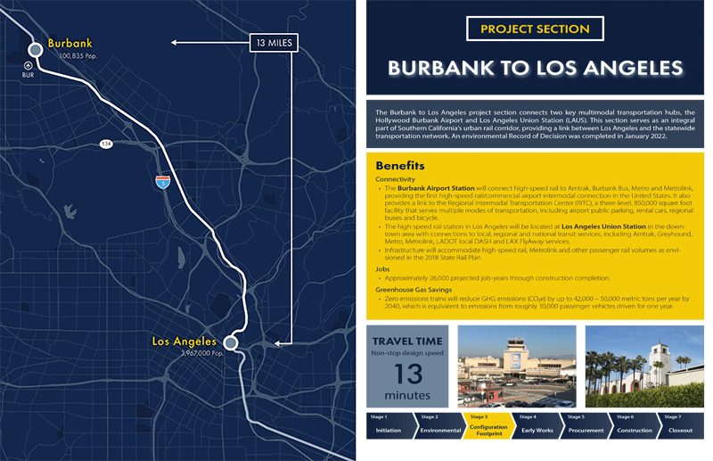
Text description of Burbank to Los Angeles Project Section
Overview
The Bakersfield to Los Angeles Project Section spread gives an example of one of the project section spreads featured in the full document. The map shows the 13-mile planned high-speed rail line from Burbank (population 100,835) to Los Angeles (population 3,967,000). Also presented are an overview of the project section including connectivity, jobs and greenhouse gas savings benefits, as well as the 13 minute non-stop design speed travel time.
The California High-Speed Rail Authority makes every effort to ensure the website and its contents meet mandated ADA requirements as per the California State mandated Web Content Accessibility Guidelines 2.0 Level AA standard. If you are looking for a particular document not located on the California High-Speed Rail Authority website, you may make a request for the document under the Public Records Act through the Public Records Act page. If you have any questions about the website or its contents, please contact the Authority at info@hsr.ca.gov.